 Queenstown City Guide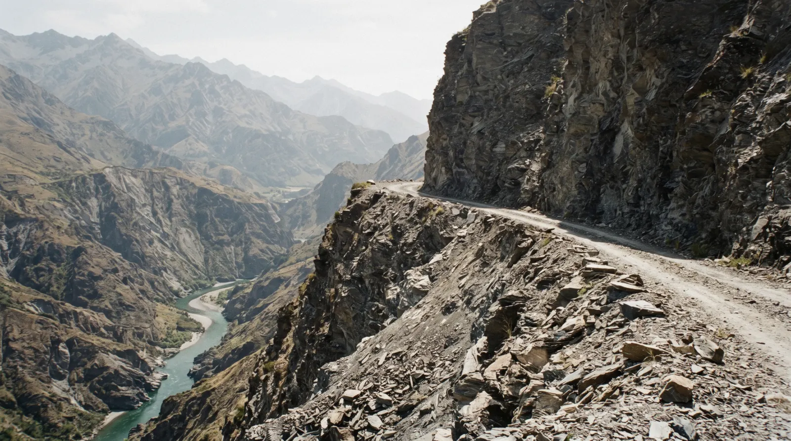
Skippers Canyon from Queenstown
Skippers Canyon is a 22 km gorge north of Queenstown, reached by a single-lane gravel road that gold miners cut into the cliffs above the Shotover River, and the most important thing to know about it in 2026 is not on most pages that describe it. Skippers Bridge, the 1901 suspension span that is the photograph everyone associates with the canyon, has been closed to all vehicles, cyclists and pedestrians since a cable inspection late in 2025, and the Queenstown Lakes District Council confirmed in a notice on 12 January 2026 that the closure remains in place until further notice, with no reopening date. This page starts there, then covers who may actually drive the road, what a booked trip reaches now, and the rental-car small print that people repeat as if it were a law. It sits under the day trips hub and inside our Queenstown guide; the river at the bottom of the canyon has its own page at Shotover Jet.
Quick answer The closure that changes the trip, who may drive, and what a seat still buys
Skippers Bridge is closed. The council's notice of 12 January 2026 states that it 'will remain closed to all vehicles, cyclists, and pedestrians until further notice', after an inspection late in 2025 found failures of the wires in the cables that suspend it, and no reopening date exists because the bridge's future has to go through the council's annual planning process. Operators still sell the canyon, in 4 hours by 4WD or 4 hours 30 minutes by raft, and the road is still open; the photograph on the bridge is not available, and any page telling you to stand on it is out of date. Prices on this site are United States dollars first with New Zealand dollars in brackets, at NZ$1 = $0.584.
Key takeaways
- Book a seat rather than a hire car: the 4WD half-day runs a six-seat vehicle up the shelf road to Lighthouse Rock, which is a viewpoint over the canyon rather than a crossing of it.
- The other way down is by water: the rafting trip buses through the canyon to reach grade 3 to 5 water on the Shotover and comes out through the 550-foot Oxenbridge Tunnel.
- No authority bans a private driver from the road, because the restriction people repeat is a rental contract term, not a council rule, and it is in your paperwork.
- The river at the bottom of the gorge is the same one the jet boat runs on, from a canyon downstream that needs no gravel road at all.
Key facts
Opening hours
| Open-access road, all year, no gate and no hours | 00:00–23:59 |
|---|
Closed None published for the road. Skippers Bridge is closed to all vehicles, cyclists and pedestrians until further notice, per the council's notice of 12 January 2026; snow, ice and slips close sections of the road without a published calendar
Admission
- Adult
- Free. The council charges nothing to use Skippers Road and no permit system is published by any authority
- Reduced
- Guided trips from Queenstown are listed at $177.94 for the 4WD half-day and $175.01 for the half-day rafting trip that buses down the canyon
- Free
- The road, the viewpoints along it and the historic reserve areas; the bridge, currently, is free and closed
Planning it
- Time needed
- Not stated by any authority. The two guided options run 4 hours and 4 hours 30 minutes; allow a full half-day either way
- Book ahead
- Recommended — a few days
- Address
- Skippers Road, off Coronet Peak Road north of Queenstown; the road controlling authority is the Queenstown Lakes District Council
Three ways into Skippers Canyon, and what each one reaches
The council's own notice next to the two seats sold from Queenstown, read from qldc.govt.nz and the GetYourGuide listings on in Q3 2026. Prices on this site are United States dollars first with New Zealand dollars in brackets at NZ$1 = $0.584; the tour cards are listed in US dollars by the platform. The first row is the road controlling authority and its link carries no tracking.
Do you want the road, or the river? That is the question here, because the bridge that used to be the answer to both is closed, and the two guided trips reach completely different parts of the canyon.
| Option | Price | What it reaches | Cancel | Book |
|---|---|---|---|---|
| Drive it yourself, council closure noticeConfident gravel drivers in a suitable vehicle whose rental agreement permits it. Read the agreement first | Free to use the road | The shelf road and its viewpoints. Not the bridge: closed to vehicles, cyclists and pedestrians until further notice | Nothing to cancel; the road closes for snow, ice and slips without notice | Official site |
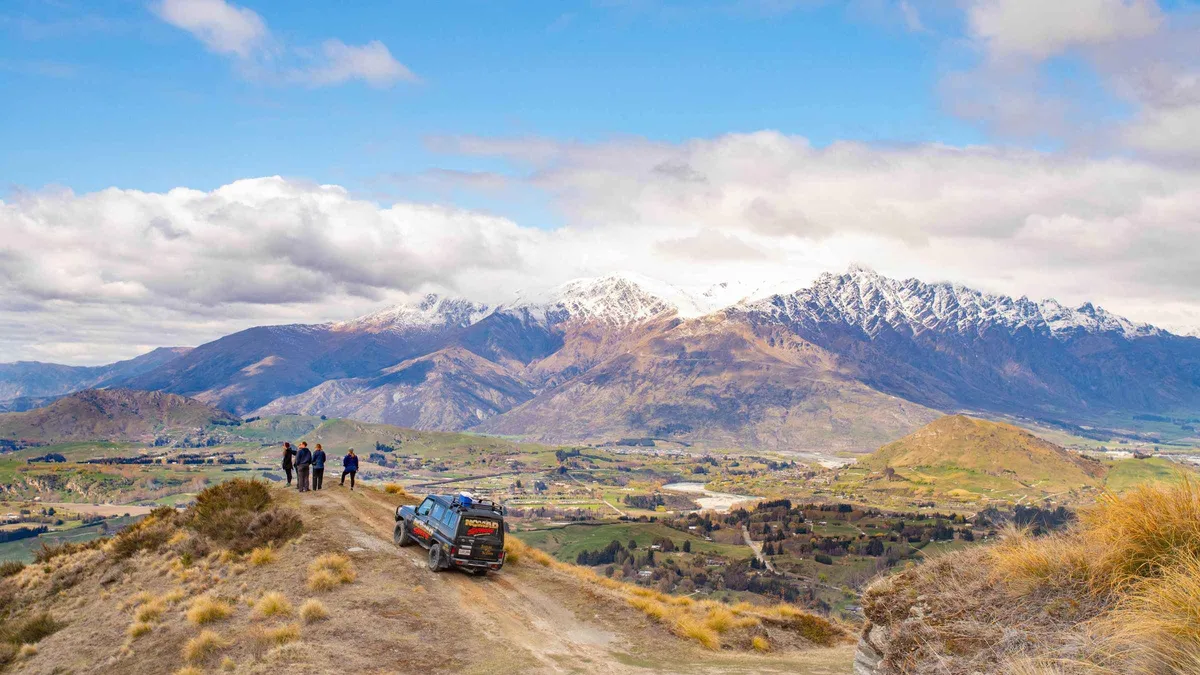
| 4WD half-day up Skippers Canyon Road, 4 hoursAnyone who wants the road itself, the history and the viewpoints without driving it | $177.94 | A six-seat Land Rover or Land Cruiser on the shelf road to Lighthouse Rock, a historic gold-mining track near Arrowtown, gold panning in the river, refreshments and lunch | Free up to 24 hours before the start time | Check Availability |
| Shotover rafting half-day, 4 hours 30 minutesPeople who want the canyon from the water and are happy to be cold and wet for an hour | $175.01 | Coach through the canyon to the put-in, grade 3 to 5 whitewater, the 550-foot Oxenbridge Tunnel, wetsuits and gear, hot showers, hotel pickup | Free up to 24 hours before the start time | Check Availability |
The two are within three dollars of each other and are not substitutes: one is a commentary-led drive with gold panning, the other is a paddling trip that uses the canyon as its access road. Both rate 4.7 and 4.8 on hundreds of reviews. Neither can put you on the bridge, and neither operator's listing mentions the closure, which is why it leads this page.
Skippers Canyon trips from Queenstown compared
Two half-days, three dollars apart, reaching the canyon by completely different means. Ratings, durations and prices are GetYourGuide's own, read on in Q3 2026, and confirmed at checkout.
 from $177.94
Queenstown: 4WD Lord Of the Rings Half-Day Tour - Queenstown
The off-road one: a six-seat 4WD up Skippers Canyon Road to Lighthouse Rock, then a gold-mining track near Arrowtown with panning in the river. Four hours, and it follows Skippers rather than the Glenorchy Road.
Check Availability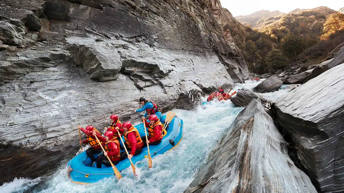 from $175.01
Queenstown: Shotover River Whitewater Rafting Adventure
Grade 3 to 5 water on the Shotover, reached by bus down Skippers Canyon, ending with the run through the 550-foot Oxenbridge Tunnel. Four and a half hours with wetsuits, hot showers and hotel pickup included.
Check AvailabilityBoth include hotel pickup from Queenstown. If neither appeals and you want the Shotover without the gravel road, the jet boat runs a different canyon on the same river, reached on sealed roads in fifteen minutes.
Prices, ratings and details are the platform's own, checked in Q3 2026; dollar figures are the listed prices — the platform bills in your account's currency.
Skippers Bridge is closed, and no page selling the canyon says so
The single most important fact about this place in 2026, published by the road controlling authority and largely absent from the pages that sell trips into the canyon.
The council's notice is unambiguous. Skippers Bridge 'will remain closed to all vehicles, cyclists, and pedestrians until further notice, after an inspection of the structure late last year found failures of the wires in the cables used to support the bridge and any load on it'. Its Acting General Manager Property and Infrastructure, Roger Davidson, is quoted: 'Investigations found failures of the wires in the cables used to suspend Skippers Bridge in place, which means we've been unable to safely assess what load the bridge can currently support and its integrity.' The council acknowledged the closure would significantly affect residents, tour companies and recreational users, and asked the public to abide by the signage and barriers and not to attempt to cross.
There is no reopening date, and the reason there is none is structural rather than seasonal: the council states that the bridge's future 'will need to be considered by Elected Members through Council's annual planning process and prioritised alongside other investment needs across the network'. That is budget language, and it means the closure is measured in planning cycles, not in weeks. The bridge was officially opened in 1901; its suspension cables roll over steel plates, drop vertically into shafts and are anchored around buried concrete dead-man anchors, and the council inspects it annually because of its age and risk profile.
That annual inspection is what found the broken wires.
| What the council published | The detail | What it means for a visitor |
|---|---|---|
| Who the closure applies to | All vehicles, cyclists and pedestrians | There is no walking across it either; this is not a weight restriction |
| Why | Failures of the wires in the cables that suspend the bridge; the load it can support cannot be safely assessed | It is an engineering unknown, which is why nothing is being let across |
| How long | Until further notice; the bridge's future goes to Elected Members through the annual planning process | No date exists to check. Treat it as closed for your trip |
| What the council asks | Abide by signage and barriers and do not attempt to cross | The barriers are not advisory |
What a booked tour actually reaches now
The canyon is not the bridge, and this is where the trips still work. The 4WD half-day's own listing describes Skippers Canyon Road to Lighthouse Rock with views over the Wakatipu Basin, an off-road section on a historic gold-mining road near Arrowtown, and gold panning in the Arrow River: a road trip along the gorge, not a crossing of it. The rafting trip uses the canyon as an access corridor, coaching down to the water and leaving by river through the Oxenbridge Tunnel.
Both remain intact with the bridge shut. What has gone is the photograph of the narrow deck, the truss and the drop, and it is worth knowing that before you book something on the strength of an image.
One caveat on our own sourcing, in the interest of not overstating it: the council's website sits behind a bot manager that refuses automated reading, so the notice above was read through a text-extraction proxy of the official page rather than fetched directly. The quotations are the council's own words from that notice. A second council page about the engineering report could not be opened at all and contributed nothing to this page.
If you are planning around the bridge, check the council's website in a browser before you travel.
The road: what it is, and why it has the reputation
Twenty-two kilometres of gorge, a single-lane shelf cut by gold miners, and the drive that half the videos on the internet call New Zealand's most dangerous road.
Skippers Road leaves the sealed Coronet Peak Road north of Queenstown and drops into the gorge on a shelf blasted and picked out of the rock in the 1880s, some 20 years after the 1862 rush, to serve the goldfields. It runs about 22 km through the gorge, narrow enough that two vehicles cannot pass except at the bays cut for the purpose, unsealed for its length, and unfenced above drops of well over 100 m in places. None of that is a legend: it is simply what a nineteenth-century mining road looks like when it has not been rebuilt.
What is legend is the ranking. No authority publishes a 'most dangerous road' list for New Zealand, and the phrase belongs to the video titles rather than to any roading agency.
Who may drive it
Here is the fact this page chased hardest, because it is stated wrongly nearly everywhere. Neither the council nor NZTA publishes any rule barring rental cars or private drivers from Skippers Road, and no permit system exists on either authority's site. There is also no published list of licensed operators for the canyon.
The restriction that everybody repeats is a term in individual rental contracts: many rental companies exclude this road from their cover, which is a matter between you and the company you hired from, not a regulation you can be fined for breaking. So the correct instruction is not 'rental cars are banned'. It is 'read your rental agreement, because if you damage the car up there and your contract excluded the road, you are paying for it'.
Driving it yourself, honestly
If you are covered and you are going anyway: a high-clearance vehicle, daylight, dry conditions and a willingness to reverse are the four things that make it a manageable drive. Reversing is the real skill, because on a single-lane shelf the vehicle with the easier retreat gives way, and that decision is made in seconds with a drop on one side. Do not go in snow or ice, do not go at dusk, and do not go if the idea of backing up a hundred metres on gravel makes you tense, because that reaction is information rather than weakness.
Everything on the road is free, including the mistakes.
What the guided vehicles do differently
Both operators run this road daily and their drivers know where every passing bay is, which is most of what safety on a shelf road amounts to. The 4WD trip uses six-seat vehicles rather than coaches, which matters for the same reason. The two trips carry 403 and 339 reviews at 4.7 and 4.8 respectively, which is a few hundred more runs down this road than any visitor will make.
That is the real argument for the $177.94 seat over a hire car: not that you cannot do it, but that the person who does it four hundred times a year does it better, and can talk about the gold workings while doing it.
Skippers in five dates
A gorge that was a goldfield before it was a scenic drive, and a bridge that outlasted the settlement it was built to serve.
-
1862
Gold on the Shotover
The Whakatipu rush reaches the Shotover and the Arrow, and the river below this gorge becomes one of the richest in the world by yield. The Arrowtown end of the same story is on the Arrowtown page.
-
The 1880s
The road is cut into the cliff
The shelf road through the canyon is picked and blasted out of the rock to serve the workings upstream; it remains single-lane and unsealed today.
-
1901
Skippers Bridge officially opened
The suspension bridge's cables roll over steel plates, drop into vertical shafts and are anchored around buried concrete dead-man anchors (Queenstown Lakes District Council).
-
Late 2025
The annual inspection finds broken wires
The council inspects the bridge every year because of its age and risk profile. The inspection finds failures of the wires in the suspension cables, and the bridge is closed.
-
12 January 2026
The closure is confirmed until further notice
The council states the bridge remains closed to all vehicles, cyclists and pedestrians, that the load it can carry cannot be safely assessed, and that its future goes to Elected Members through the annual planning process.
Sources: the Queenstown Lakes District Council's closure notice of 12 January 2026, read through a text proxy of the official page because the council's site refuses automated reading, and the English Wikipedia article on Skippers Canyon for the gorge's 22-kilometre length. The gold-rush background is covered in the Shotover gold rush.
How much time to give Skippers Canyon
Three routings, built from the operators' stated durations and the road's own character, with the door-to-door figure a Queenstown hotel actually sees.
No authority publishes a driving time for this road, which is consistent with everything else about it, so the anchors are the operators' own durations: four hours for the 4WD trip and four and a half for the rafting. Both include hotel pickup, so those are close to door-to-door figures already. Driving it yourself is slower than people expect, because the pace is set by the passing bays rather than by the distance.
| Routing | In the canyon | What it skips | Door to door from Queenstown |
|---|---|---|---|
| 4WD half-day, guided | The shelf road to Lighthouse Rock, the mining road, gold panning | The river; you look down at it | 4 hours, with hotel pickup |
| Rafting half-day | The canyon by coach, then the river itself and the tunnel | The viewpoints and the history commentary | 4 hours 30 minutes, with hotel pickup |
| Self-drive, own vehicle | As far as your nerve and the conditions allow | Nothing, except the commentary and the insurance | Half a day, and longer if you meet traffic |
Those three lines are our routing rather than a published figure. What is official is the closure, and it removes one stop from every version of the day. Pair the canyon with something on the same side of town rather than trying to add a second long drive: Arrowtown is the natural other half of a gold-rush day and the 4WD trip already goes there, while the adventure activities hub has the rest of what a half-day in Queenstown can hold.
Weather, season and what goes wrong
The honesty layer for a road with no gate, no ticket and nobody to tell you it has gone bad.
The road is open access all year and nothing announces its condition to a visitor. Snow, ice and slips close sections of it without a published calendar, and unlike a ski access road there is no daily report to check at 06:30. In winter the shaded sections of a south-facing gorge road hold ice long after the town is clear, which is the single most common way a confident driver gets into trouble here.
Neither guided operator publishes a weather-cancellation cutoff; both offer free cancellation up to 24 hours before the start time, which is the standard platform term rather than a weather policy.
The rafting trip carries a second variable that the road does not: river level. Grade 3 to 5 water is graded at a normal flow, and a river in flood or very low is a different proposition. The operator's listing states no minimum age and no wheelchair provision either way, so if either matters to your group, ask before booking rather than at the base.
The trip runs 4 hours 30 minutes against the 4 hours of the 4WD day, and wetsuits, safety equipment, hot showers and hotel pickup are all included, which is worth knowing because a cold half-day is a much better one when the shower at the end is part of the price.
What to check the night before
Three things, in order. The council's website for anything new about the bridge or the road, in a browser rather than an app, because the council's own pages resist automated reading. The forecast, specifically for ice rather than rain.
And your rental agreement, if you are driving. None of that takes ten minutes, and it is the difference between a half-day out and an expensive phone call. Queenstown safety and hazards has the wider version of this for the district.
Skippers Canyon: what to do and what to avoid
Six decisions to make before you leave Queenstown, each argued somewhere above.
Do this
- Read the council's closure notice before you plan any photograph on the bridge
- Read your rental agreement's clause about unsealed and excluded roads before you drive
- Take the guided 4WD half-day if you want the road without the reversing
- Go in daylight and in the dry, and turn around early if the surface has ice on it
- Pair it with Arrowtown rather than a second long drive; the same trip already goes there
- Ask the rafting operator about age and mobility before booking; the listing states neither
Not this
- Do not attempt to cross the bridge on foot; the closure covers pedestrians and cyclists as well
- Do not believe a page that tells you rental cars are banned by the council; no authority publishes that
- Do not treat 'most dangerous road' as an official ranking; no agency publishes one
- Do not drive it at dusk, in snow, or without room to reverse a hundred metres
- Do not expect a road report; nothing publishes daily conditions for this road
- Do not assume free cancellation covers the weather; it is a 24-hour platform term
Sources: the Queenstown Lakes District Council's closure notice of 12 January 2026 and its statements about the bridge's construction and inspection regime, plus the two GetYourGuide listings, all read on in Q3 2026.
Five things most visitors do not know about Skippers Canyon
- Skippers Bridge is closed to all vehicles, cyclists and pedestrians until further notice, and the operators selling the canyon do not mention it in their listings (Queenstown Lakes District Council notice, 12 January 2026).
- There is no reopening date because the bridge's future has to be considered by Elected Members through the council's annual planning process, alongside other investment across the network (Queenstown Lakes District Council).
- No authority bars rental cars or private drivers from the road: the council and NZTA publish no such rule and no permit system, so the restriction is a term in individual rental contracts (Queenstown Lakes District Council and NZTA, searched on the date in the freshness box).
- There is no published list of licensed Skippers Canyon operators either, despite how often 'only permitted operators' is repeated (same search).
- The bridge's cables roll over steel plates and drop into vertical shafts anchored around buried concrete dead-man anchors, and it is inspected annually because of its age and risk profile, which is how the broken wires were found (Queenstown Lakes District Council).
Skippers Canyon on a map: the road in, the bridge, the river
The gorge runs north from the Coronet Peak road, above the Shotover. The canyon point is the published coordinate for the feature; the bridge point is approximate, from this site's research pack, because no authority publishes a coordinate for it.
Coordinates: the canyon from its published point, the Coronet Peak point from the Land Information New Zealand gazetteer entry for the recreation reserve, the bridge approximate from this site's research pack. The council publishes no coordinate for the bridge.
What pairs with Skippers Canyon, and what does not
It is a half-day on one side of town, which makes it one of the easier trips to pair. These are the three that fit.
Shotover Jet
If the gravel road is the part you do not want, the jet boat puts you on the Shotover in the Shotover Canyon downstream, with no unsealed driving at all.
The same river, a different canyon, fifteen minutes from town on sealed roadsGlenorchy
The same instinct, a road worth driving for its own sake, with more open landscape and less exposure. Glenorchy is the version of this day you can do in a normal car.
The other unsealed-road day, up the lake in the opposite directionAdventure activities
The rafting trip that buses down this canyon sits alongside the bungy, the jet boats and the rest on the adventure activities hub, with the prices and the age limits side by side.
In and around townSkippers Canyon: questions
Can you drive to Skippers Canyon?
The road is a public, open-access road and no authority publishes a rule barring private drivers or rental cars from it, nor any permit system. What stops most visitors is their rental contract: many companies exclude this road from cover, and that is a term in your agreement rather than a regulation. If you are covered, go in daylight, in the dry, in a vehicle with clearance, and expect to reverse to a passing bay. The section above sets out the honest version of what the drive involves.
Is Skippers Bridge open?
No. The Queenstown Lakes District Council's notice of 12 January 2026 states that the bridge will remain closed to all vehicles, cyclists and pedestrians until further notice, after an inspection late in 2025 found failures of the wires in the cables that suspend it. The council says it has been unable to safely assess what load the bridge can support, and that its future goes to Elected Members through the annual planning process, so there is no reopening date to check. Abide by the signage and barriers; the full notice is quoted above.
What is Skippers Canyon Road?
It is a single-lane gravel shelf road cut into the cliffs of a 22-kilometre gorge north of Queenstown in the 1880s, to serve the goldfields upstream, and it has not been substantially rebuilt since. It leaves the sealed Coronet Peak Road, has passing bays rather than two lanes, and is unfenced above long drops. The council is the road controlling authority. It publishes no daily condition report for it, which is part of what makes winter driving there a bad idea.
Is Skippers Canyon Road really the most dangerous road in New Zealand?
No agency publishes such a ranking, so the claim has no authority behind it, and it belongs to video titles rather than to the roading record. What is true and checkable is the physical description: single lane, gravel, passing bays, unfenced, with drops to the Shotover. That is enough to take seriously without a superlative attached. Both guided operators run it daily with drivers who know where every bay is, which is the practical answer for anyone unsure.
Is Skippers Canyon the same as canyoning, and is canyoning in Queenstown worth it?
They are different things and the search results conflate them. Skippers Canyon is a gorge and a road; canyoning is a guided activity in which you abseil, jump and slide down a watercourse, and it runs in other canyons around Queenstown rather than in this one. Whether canyoning is worth it is a question for the operators who sell it, and it is not this page's subject: the seats sold into this gorge are a 4WD road trip and a rafting trip. The adventure activities hub is where the wet and vertical options are compared.
What is there to do in the canyon now the bridge is shut?
Two things, and both are still intact. The 4WD half-day runs the shelf road to Lighthouse Rock for the views over the Wakatipu Basin, then an old mining road near Arrowtown with gold panning in the river, for $177.94 over four hours. The rafting trip coaches down the canyon to grade 3 to 5 water on the Shotover and exits through the 550-foot Oxenbridge Tunnel, $175.01 over four and a half hours. What has gone is standing on the bridge.
How much does a Skippers Canyon tour cost?
The two seats sold from Queenstown are within three dollars of each other: $177.94 for the four-hour 4WD trip, which includes a six-seat vehicle, a driver-guide, gold panning, refreshments and lunch, and $175.01 for the four-and-a-half-hour rafting trip, which includes transfers, all the rafting and safety gear, hot showers and hotel pickup. Both cancel free up to 24 hours before the start time. The road itself costs nothing to drive.
Is there a bungy in the canyon?
Not on this page's road. The bungy people associate with the Shotover is the canyon swing operation downstream in Shotover Canyon, reached on sealed roads, and the two bridges people jump from in this district have their own pages: Kawarau, which is the original, and the Nevis, which is the highest. Nothing commercial jumps from the closed 1901 bridge, and nothing did before it closed either.
When is the best time of year to go?
Between late spring and early autumn, in dry weather and in daylight. The gorge is south-facing in places and holds ice in its shaded sections long after Queenstown itself is clear, and nothing publishes a daily condition report for the road, so winter driving there is done on your own judgement with no information. Neither guided operator publishes a weather-cancellation cutoff; both simply cancel free up to 24 hours ahead, which is a booking term rather than a weather policy.
Our verdict: take the seat
Book the 4WD half-day at $177.94 if the road and the gold-mining history are what you came for. It is four hours, it includes the pickup, the vehicle is six-seat rather than a coach, and it hands the passing-bay arithmetic to someone who does it daily. Take the rafting trip at $175.01 instead if you would rather be on the river than above it; it uses the same canyon as its road in and comes out through the tunnel.
Drive it yourself only if your rental agreement covers the road, the day is dry, and reversing on gravel does not worry you. And whichever way you go, adjust your expectations about the bridge before you leave rather than at the barrier: it is closed to everyone, there is no date, and the council has asked people not to try. The day trips hub has the alternatives if that changes your mind about the morning.
Skippers Canyon on Film: the Road, the Drive and the Guided Trip
Three films that show the shelf road as it actually is: the drive end to end, how far a vehicle gets, and the guided version from the passenger seat.
Driving the Worlds Second most Dangerous Road - Skippers Canyon
The road driven end to end, which is the best way to judge whether you want to do it yourself.
Video: Dave WhyteSkippers Canyon How Far can we Drive?
How far a vehicle actually gets along the canyon, filmed recently enough to be useful.
Video: Real Neil 4WDWith Nomad Safaris Queenstown into Skippers Canyon Road - Lord of the Rings Queenstown Tour
The guided 4WD trip from the passenger seat, for anyone weighing the seat against a hire car.
Video: Virtual Journeys with Michael NeesVideos load from YouTube only when you press play.
Reviewed Q3 2026 (July–September 2026); next review Q4 2026. Prices, hours and terms are set by the venue or operator and confirmed at checkout.
We may earn a commission if you book through one of our links, at no extra cost to you. Full affiliate disclosure